The Redistricting process & Why it matters
Redistricting is meant to redraw voting districts to ensure fairer representation for each resident. Every 10 years, local governments use new data from the U.S. Census to review their voting district boundaries to determine whether they need to be adjusted to reflect any changes in the local population and its distribution amongst the current districts. The Santa Clara Valley Open Space Authority will be engaging in that process over the next few months, and it is asking for your help to plan, draw, and identify new Authority voting districts (“director districts”). The primary goal when developing voting districts is to draw lines that respect neighborhoods, communities of interest, shared history, and geographical elements. As such, the Authority wants your important and valuable input!
How you can participate
Share your specific thoughts, draw a map, or attend an upcoming public hearing to get involved!
- Submit written testimony about the process or a specific map to clerk@openspaceauthority.org
- See the table below to view a calendar of public hearings at which you can speak about the process or a specific map.
- Scroll down on this page for more information on drawing and submitting maps.
As a participant in the process, you can:
- Define your neighborhood or community of interest;
- Explain why redistricting is relevant to your community;
- Get the tools you need to draw a map of one district or of all the districts;
- Share your opinions of the draft maps; and
- Talk to your neighbors and local organizations!
Timeline
Meeting Type |
Date, Time, Location |
Information |
| Informational Presentation | November 18, 2021 @ 6:30 p.m. Virtual only |
|
| Informational Presentation & Adoption of Criteria |
January 27, 2022 @ 6:30 p.m. Members of the public may participate in the meeting by joining this link: https://us02web.zoom.us/j/87603505925 or by calling the following number: 1-699-900-9128; when prompted enter access code 876 0350 5925 |
|
| Deadline for Members of the Public to Submit Draft Maps for Consideration at Public Hearing #1 | Friday, February 11, 2022 @ 5:00 p.m. | Draw a Map Using DistrictR here |
| Public Hearing #1 |
Thursday, February 24, 2022 @ 6:30 p.m. Virtual Only Members of the public may participate in the meeting by joining this link: https://us02web.zoom.us/j/86064036744 or by calling the following number: 1 699-900-9128; when prompted enter access code 860 6403 6744 |
|
| Deadline for Members of the Public to Submit Draft Maps for Consideration at Public Hearing #2 | Thursday, March 3, 2022 @ 5:00 p.m. | Draw a Map Using DistrictR here |
| Public Hearing #2 |
Thursday, March 10, 2022 @ 6:30 p.m. Members of the public may participate in the meeting by joining this link: https://us02web.zoom.us/j/86343690759 or by calling the following number: 1 699-900-9128; when prompted enter access code 86343690759 |
|
| Deadline for Members of the Public to Submit Draft Maps for Consideration at Public Hearing #3 |
Friday, April 1, 2022 @ 5:00 p.m. |
Draw a Map Using DistrictR here |
| Public Hearing #3 |
Thursday, April 14, 2022 @ 6:30 p.m. Members of the public may participate in the meeting by joining this link: https://us02web.zoom.us/j/87020948237 or by calling the following number: 1 699-900-9128; when prompted enter access code 870 2094 8237. |
|
| Legal Deadline to Adopt Map | Sunday, April 17, 2022 | Cal. Elec. Code § 21622(a)(3) |
Draw a map yourself!
Redistricting is different than most issues that come before the Board of Directors. Instead of being limited to saying you support or oppose an Authority-prepared policy or resolution, you can draw a map yourself using DistrictR, a simple online map drawing tool to easily draw neighborhoods or communities of interest!
Click here to view the DistrictR website!
Community Submissions
Below are maps submitted by community members:
- SCVOSA Plan 1A Nakamura Atlas
- SCVOSA Plan 1A Nakamura Web Map
- SCVOSA Plan 2A Nakamura
- SCVOSA Plan 2A Nakamura web-map
Maps received after the March 3 submission deadline and publication of the agenda:
- SCVOSA Plan 2B Nakamura (PDF)
- SCVOSA Plan 2A2 and 2A3 (PDF)
Maps received by the April 01 submission deadline by community members:
- SCVOSA Plan 1B1 Nakamura Atlas
- SCVOSA Plan 1B1 Nakamura Web Map
- SCVOSA Plan 2B1 Nakamura Atlas
- SCVOSA Plan 2B1 Nakamura Web Map
- SCVOSA Plan 2B2 Nakamura Atlas
- SCVOSA Plan 2B2 Nakamura Web Map
- SCVOSA Plan 2C1 Nakamura Atlas
- SCVOSA Plan 2C1 Nakamura Web Map
- SCVOSA Plan 2C2 Nakamura Atlas
- SCVOSA Plan 2C2 Nakamura Web Map
- SCVOSA Plan 2E1 Nakamura Atlas
- SCVOSA Plan 2E1 Nakamura Web Map
- SCVOSA Plan 3A1 Nakamura Atlas
- SCVOSA Plan 3A1 Nakamura Web Map
- SCVOSA Plan 1B2 Nakamura Atlas
- SCVOSA Plan 1B2 Nakamura Web Map
- SCVOSA Nakamura Plan 2E2
- SCVOSA Nakamura Plan 2E2 webmap
- SCVOSA Nakamura Plan 3A2
- SCVOSA Nakamura Plan 3A2 webmap
Below are public comments submitted by community members:
- Public Comments (2/24/22 Meeting)
- Public Comments (3/10/22 Meeting)
- Public Comments (Received 03/22/2022)
- Public Comments (04/14/2022 Meeting, Updated 4/15/22)
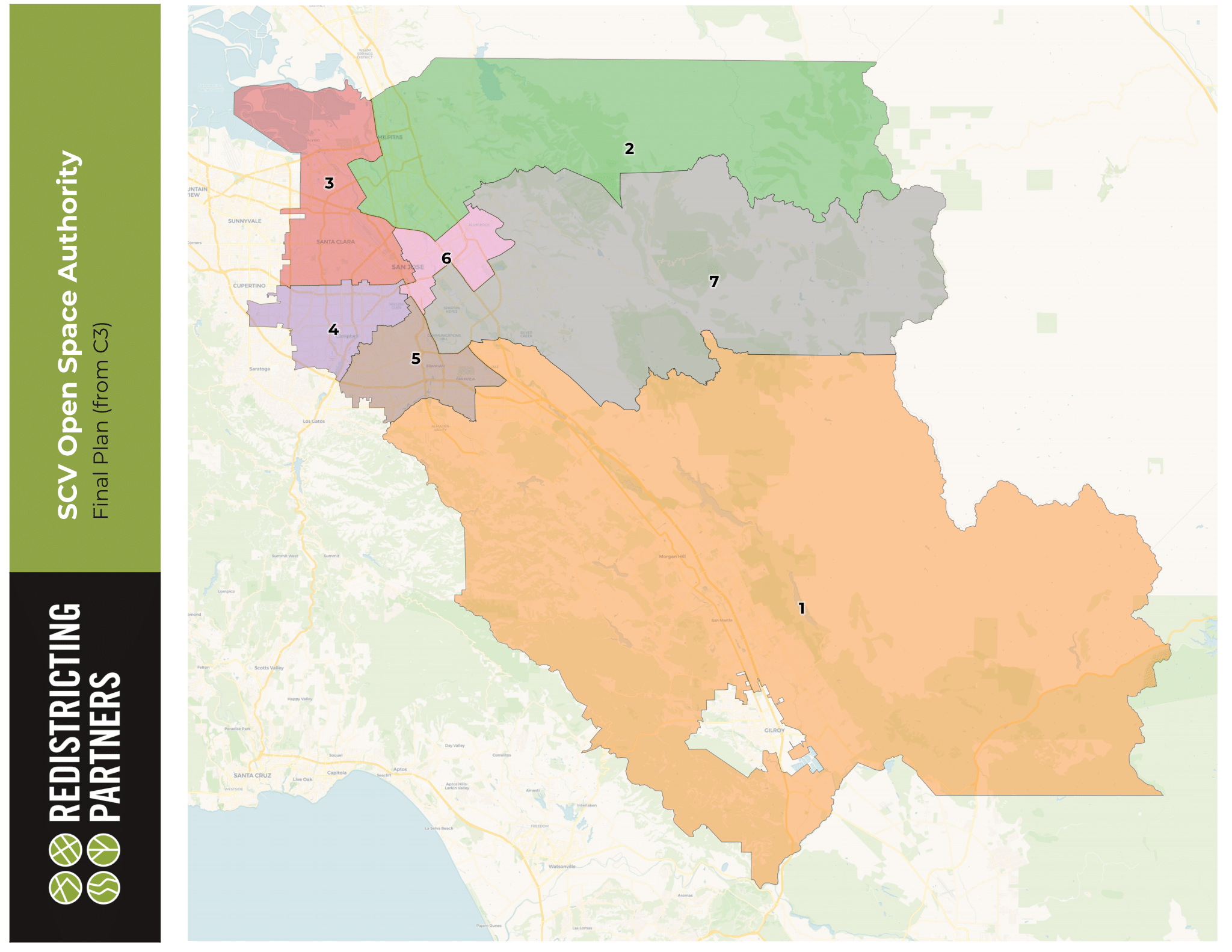
Draft Maps
Below are all of the draft maps submitted by 5:00 p.m., February 24, 2022. Click on the link for a printable version of each proposed map, including a page providing the demographic summary of each district for each map.
Redistricting Partners:
- Draft Plan A
- Draft Plan A web-map
- Draft Plan B
- Draft Plan B web-map
- Draft Plan C
- Draft Plan C web-map
Below are all of the draft maps submitted by 5:00 p.m., March 3, 2022. Click on the link for a printable version of each proposed map, including a page providing the demographic summary of each district for each map.
Below are all of the draft maps submitted by 5:00 p.m., April 1, 2022. Click on the link for a printable version of each proposed map including a page providing the demographic summary of each district for each map.
-
Specification of Criteria to Guide the Realignment of Director Divisions
- 1. The boundaries of the director divisions shall be realigned so that the director divisions are equal in population as defined by law.
2. The boundaries of the director divisions shall not be gerrymandered in violation of the principles established by the United States Supreme Court in Shaw v. Reno, 509 U.S. 630 (1993), and its progeny.
3. The boundaries of the director divisions shall be realigned so that the director divisions do not result in a denial or abridgement of the right of any citizen to vote on account of race or color as provided in Section 2 of the federal Voting Rights Act.
4. The boundaries of the director divisions shall observe communities of interest, developed primarily around the current director divisions, but also including rural or urban populations, municipalities, county supervisorial districts, city council districts, social interests, agricultural, industrial or service industry interests, and the like, insofar as practicable.
5. The boundaries of the director divisions shall be compact, insofar as practicable.
6. The boundaries of the director divisions shall be created to contain cohesive, contiguous territory, insofar as practicable.
7. The boundaries of the director divisions may observe topography and geography, such as the existence of mountains, flat land, forest lands, man-made geographical features such as highways and canals, etc. as natural divisions between director divisions, insofar as practicable.
8. Unless otherwise required by law, the director divisions shall be created using whole census blocks.
9. The boundaries of the director divisions may avoid the “pairing” of incumbents in the same director divisions, insofar as this does not conflict with the constitutions and laws of the State of California and the United States.
10. The boundaries of the director divisions shall comply with such other factors which become known during the redistricting process and are formally adopted by the Board of Directors.
-
Board Approved Map